Inhalt
Pirna facts & figures
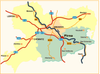
Pirna is located at the upstream end of the Dresden Basin, where the nearby rivers Wesenitz, in the North, and Gottleuba to the South, flow into the Elbe river. East of Pirna, the Elbe rolls through the Elbe Sandstone Mountains ("Elbsandsteingebirge") in a transverse valley which reaches right into the city – hence Pirna's nickname "The Saxon Switzerland City".
Coordinates: 50°57′44″N 13°56′25"E
Elevation: 109 – 340 m
Area: 53 km² (20.47 sq mi)
Surrounding communities: Dresden, Bad Gottleuba-Berggießhübel, Bahretal, Dohma, Dohna, Dürrröhrsdorf-Dittersbach, Heidenau, Lohmen, Stadt Wehlen, Struppen
Population: 38.252 (31.12.2010); density: 736 people per km²
State: Saxony
Administrative district: Saxon Switzerland-Eastern Ore Mountains ("Sächsische Schweiz-Osterzgebirge")
Post code: 01796
Area code: 03501
License plate: PIR
Town subdivisions: 10 districts
- Inner city (including Obervogelgesang and Niedervogelgesang)
- Sonnenstein/Cunnersdorf
- Rottwerndorf/Neundorf/Krietzschwitz
- Zehista/Zuschendorf
- Copitz-West
- Copitz-Ost (including Posta)
- Jessen/Liebethal
- Mockethal/Zatzschke
- Graupa/Bonnewitz
- Birkwitz/Pratzschwitz
Incorporations: Originally, Pirna included the old town and the four historic suburbs Fischergasse, Schifftorvorstadt, Dohnaische Vorstadt and Obertorvorstadt. The districts which lay beyond the city walls, and which later became Westvorstadt, Südvorstadt and the Sonnenstein residential estate, also belonged to the city. Later on, Pirna expanded as follows:
- 1850 Hausberggemeinde
- 1922/23 Posta, Niedervogelgesang, Zuschendorf, Neundorf, Rottwerndorf, Hinterjessen and Copitz
- 1931 Zehista
- 1950 Cunnersdorf, Mockethal and Zatzschke
- 1971 Liebethal
- 1974 Krietzschwitz, Obervogelgesang
- 1999 Birkwitz-Pratzschwitz, Graupa
